Is
the sea ice coming to the Baltic Sea
early this winter ?
Posted 10 October 2010
 The
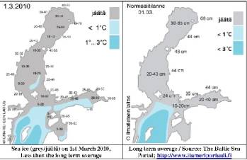
period and extent of sea icing in Northern Europe may give
interesting climatic change indications, and more important which
influence may human activities have had. The last winter 2009/2010
was the coldest since 1987, put the sea ice cover remained far
behind (see: Fig.). Did the high number of 2000 sizable merchant
ships navigating the Baltic Sea prevented to forming of sea ice? The
winters succeeding the last winter severely had been four very cold
winters in the 1940s. While the ice cover was about 50%, in 1987 it
reached almost 90% and in the first three World War II years and
1946/47 the Baltic Sea was covered completely.
A
fully ice cover happened in the winter 1939/40, the first time since
1883. To the people it came out of the blue. No one had predicted a
unusual winter, no one had imaged an extreme winter. Such assertion
for the winter to come has now been made by Polish scientists: They
that the Atlantic Gulf Current lost strength, and reduce the usual
heat 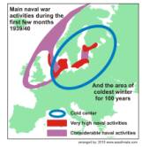 supply
for a warmer Europe considerably. While little can be done about
that, recalling a bit how the ice developed in the extraordinary
winter 1939/40 is also some sort of preparation. As source we use
the monthly weather reports by the Swedish Meteorological Service
 Throughout
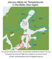
the autumn 1939 high pressure prevailed all over Scandinavia, and a
widely persistent wind flow from the north. The icing of seas and
rivers started in the northern und middle part of Norrland, in the
north of the NW of Svealand in the mid of October,
about 2 weeks earlier then usually. The first ice reports
from the ports Toe and Lulea came in on the 2nd of
November. It remained modest throughout the month, and only since
the 27th of November sea ice appeared in other ports,
including Hasparand and Karlsborg. On the 30th November
the Soviet Union ambushed Finland, by land, sea and air, which
increased the activities at sea in the Gulf of Finland tremendously,
while any naval activities in the Gulf of Bothnia remained
negligible.
During
a few cold periods until 21st December the ice extended
south and reached Kalmarsund by the end of the month. Further
details by a brief extraction from a book:
___”In
Hanko/Finland (at the west entrance to the Gulf of Finland), icing
started on December 27, 1939; solid ice formed on January 4, 1940;
end of ice came on May 7, 1940.; at almost the same time as
Helsinki. However, on January 15, 1940 the Gulf of Finland was still
open as far East as the median of Pellinki. Ice then formed rapidly. Just to remind. Although
the Gulf of Bothnia is far in the North it is with over 200 metres
– in the Baltic Sea area -the deepest water, holding considerable
heat for considerable time even in cold winters. An ‘ice-bridge’
between Turku and the island of Åland formed on January 6/7, 1940,
which is about 2 ½ weeks earlier than usual.”

Attention
should be drawn to tow interesting distinct deviation from the
average.
- The early ice forming inland ,
coastal areas, and Åland islands, which was presumably due to
the generally low sea surface temperatures (and inflow of cold
air from the Arctic) due to naval activities throughout Northern
Europe, and
- The long lasting open sea in
the Gulf of Finland, which indicates that due to military
activities a high mixing of water took place preventing the
formation of ice.
The
sea ice closed around Gotland in early February, and it become the
first winter since 1883 that covered the whole Baltic Sea with ice
about two weeks later. If the coming winter will be again severe, it
will be interesting to compare the developments with those which
happened 71 years ago.
Further reading:
Book section 2_17: Baltic Sea paved way for extreme winter
http://www.climate-ocean.com/02_17-Dateien/02_17.html
Short texts:
Reference:
Figure 1 & 4: The BALTIC SEA PORTAL is maintained
by the Finnish Environment Institute, the Finnish Meteorological Institute and
the Ministry of Environment in Finland. http://www.itameriportaali.fi/en/info/en_GB/info/
Statens
Meteorologisk Hydrografiska Anstalt, Argång 21 & 23.


